


19 facts about Masada
The ancient fortress located on the Dead Sea was the site of bloody battles between Jewish insurgents and the Romans.
The Zealots' attitude in defendi ...
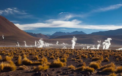
The Negev Desert in Israel is a large desert plateau covering a large area of the southern part of the country. It is desert land, although unusual because it is rocky. There are only seasonal rivers, only a few cities, but many settlements, kibbutzim, and moshavs.
It is a highland area located at an altitude of 500 to 900 meters above sea level.
It forms the shape of an inverted triangle, the sharp apex of which points towards Eilat, a city in southern Israel on the shores of the Gulf of Aqaba on the Red Sea.
The western side of the Negev adjoins the desert of the Sinai Peninsula (a peninsula in Egypt and the only part of the country located in Asia), extending into the Judean Desert, the Judean Mountains, and the coastal plain. Its eastern border is the Arabah Valley (the geographical area south of the Dead Sea basin, forming part of the border between Israel and Jordan).
There are brown mountains cut by wadi (dry seasonal river beds) and deep craters.
The landscape in the south is much more varied, dotted with mountains, valleys, and erosion craters. In the Negev Mountains, there is the highest peak of the desert and the highest point in southern Israel-Har Ramon, reaching 1037 meters above sea level.
It is one of the most spectacular geological formations in the desert. It is located approximately 85 kilometers south of the largest city in the Negev-Beersheba. The crater is 40 kilometers long, 9 kilometers wide, and 300 meters deep. It has the shape of an elongated heart.
The crater was created by land erosion. Hundreds of years ago, the Negev Desert was covered by the ocean. As the waters receded north, a hill in the form of a hump was exposed. The hump was gradually flattened by water and climatic conditions. The flowing water had gouged out the interior of the crater (softer rock), the bottom of which was deepening at a much faster rate than the surrounding walls.
As the crater deepened, the oldest rock deposits were exposed, which were up to 200 million years old. At the deepest point of the crater, there is the only natural water source - Ein Saharonim, which supplies most of the wild animals living there.
They ranged in size from the size of a snail to tractor wheels. Most of them have been excavated.
The hill was once an active volcano that erupted thousands of years ago and covered it with lava, creating basalt rock. Nearby is Shen Ramon (Ramon’s Tooth), a rock formed from magma that solidified underground. Through cracks in the ground’s surface, this rock later emerged to the surface, contrasting with the nearby cream-colored southern walls of the crater as a black rock with sharp edges.
The eastern part of the crater contains several vertical dykes (rock that forms in a crack in pre-existing rock). At some of them, you can find geodes (a space of a rock mass filled with a mineral) of celestine (a mineral consisting of strontium sulfate).
It is characterized by a continental climate with large temperature differences between winter and summer and day and night. The hottest part of the Negev is the southern part of the Dead Sea depression with an average annual temperature of 25 degrees Celsius (16 degrees Celsius in January and 34 degrees Celsius in August). The least hot part of the region is the highlands of the central Negev, with an average annual temperature of 17 degrees Celsius.
The Negev is a dry desert - with rainfall from 25 to 200 millimeters per year, air humidity that drops to 10 percent during hamasin (dry, hot local wind), and temperatures up to 45 degrees Celsius.
The fauna of the Negev also belongs to the desert type and includes several endemic species. Mammals that have adapted to life in the desert include: Dorcas gazelles, Nubian ibexes, striped hyenas, Ethiopian hedgehogs, Ethiopian rock hyraxes, and others.
It is located in the Rimna Valley, north of the Gulf of Aqaba. This is a region where copper was mined in ancient times (already in the second half of the 2nd millennium BC, the Egyptians mined copper here). The world’s oldest furnace for smelting this raw material was found in the park. In addition to ancient copper mines, there are remains of the city. Remains of the Egyptian temple of Hathor and the bronze serpent Timna were also found, showing traces of gold plating on its head.
Timna National Park also features extremely impressive rock formations called Solomon’s Columns, with Egyptian inscriptions preserved on the upper part. Other mushroom-shaped rock formations characterize the overall image of this park.
The city often called the “capital of the Negev” is also one of the largest cities in Israel. In terms of population, Beersheba is the seventh city in Israel.
It is located in the vast Be’er Sheva valley, through which the Be’er Sheva, Kowshim, and Katef streams flow. The valley is a green oasis located in the middle of the Negev Desert.
Beersheva is a city mentioned several times in the Bible. The city already existed during Abraham’s lifetime. According to the Bible, it was here that Abraham dug a well (which still exists today), planted tamarisk trees over it, and later made a covenant with King Abimelech. That’s why the place was called Beer Sheva, i.e. “The Well of the Oarh.” At that time, the valley had plenty of water, as evidenced by the remains of numerous wells.
It is one of the fastest-growing universities in Israel. Its activities are focused on promoting the idea of developing the Negeb region.
After the collapse of the Soviet Union, many famous professors from universities in Leningrad, Riga, Moscow, Kharkiv, and others settled here. Next to the university, there is a world-famous center for research on desert nature.
To the west of Beersheva is the large Israeli Air Force base of Khatzerim. In 1977, the famous aviation museum was opened here.
The Advanced Technology Park is also being developed here, which is to focus on the cybersecurity, nanotechnology, and telecommunications sectors in the city. The military also plans to open an Israeli cybersecurity center in Beersheba.
Israeli Prime Minister Benyamin Netanyahu announced that the city is to become the cybersecurity capital of the world.
By 2010, the Negev was home to approximately 630.000 people, representing 8.2 percent of Israel’s population. 75 percent of the population are Jews and 25 percent Bedouins. Half of the Bedouin population are rural communities living in unrecognized villages, and the other half live in cities built for them by the Israeli government in the 1960s and 1980s. The largest of these cities is Rahat.
It is expected to accommodate 10.000 military personnel and 2500 civilian personnel.
That’s why the desert has become the center of Israel’s solar industry. There are opinions of experts in the field of solar energy that the construction of solar power plants in the Negev will meet Israel’s energy needs in the future.
Currently, they are established in the northern hills using innovative computerized irrigation methods. The first of the major wineries in the Negev was Carmel Winery.
Carmey Avdat is the first solar-powered winery in Israel.
It includes a nuclear reactor at the Negev Nuclear Research Center, 22 agrochemical and petrochemical factories, an oil terminal, closed military zones, quarries, a toxic waste incinerator, cell towers, a power plant, several airports, and a prison. The city of Tel Aviv disposes of its waste in the Negev. This industrial area poses a threat to the nature of the Negev.
The most famous proponent of this idea was David Ben-Gurion (the first Prime Minister of Israel), who himself moved to Kibbutz Sade Boker to help settle the desert.
Innovative agricultural methods (rainwater use based on ancient models) are being developed, tested, and used in the Negev. Fish farming is a developing industry.
Large deposits of phosphates are intensively exploited and processed there, and bromide extracted from the Dead Sea is processed in the Negev. The following are also extracted: potassium carbonate, bromine, magnesium, clay, gypsum and marble, natural gas, and quartz sand.
In the desert, several large heavy industries employ thousands of workers. Tourism also plays an important role in the economic use of the Negev. Tourists are attracted by the mountains of the central Negev and the resorts of Eilat.