Easter Island
Geography

Facts about Easter Island

We found 29 facts about Easter Island

Rapa Nui

Easter Island (Rapa Nui) is a corner and special territory of Chile in the Pacific Ocean, one of the world's most remote inhabited places. It is small, with an area of about 164 km2 (64 sq mi), but despite its small size, it is a place of fascinating history, full of secrets. Its inhabitants have created a unique culture, as evidenced by the stone moai and other artifacts. UNESCO has declared the island a World Heritage Site.
Easter Island
1
Easter Island is an island and special territory of Chile in the southeastern Pacific Ocean, at the southeasternmost point of the Polynesian Triangle in Oceania.
The Polynesian Triangle is a region of the Pacific Ocean with three groups of islands at its tips: Hawaii, Easter Island, and New Zealand. The term is often used to define Polynesia.
2
The name "Easter Island" was given to it by a European - the Dutch explorer Jacob Roggeveen.

He came across it on Easter Sunday in 1722 while looking for Davis Land, a supposed island that had been put on maps for some time but was later found not to exist. The island was believed to be in the Pacific Ocean, near South America.

Its name came from the pirate Edward Davis, who reportedly spotted it in 1687 while sailing across the Pacific south of the Galapagos Islands toward Cape Horn. Davis made raids on Spanish settlements along the coasts of Mexico, Peru, and Chile.

3
Roggeveen called it Paasch-Eyland (the 18th-century Dutch name for "Easter Island").
The official Spanish name of the island Isla de Pascua also means "Easter Island." The current Polynesian name for the island, Rapa Nui ("Big Rapa"), originated in the early 1860s and refers to the island's topographical similarity to Rapa Island (sometimes called Rapa Iti, or "Little Rapa," the largest and only inhabited island of the Bass Islands in French Polynesia. In the local language, the island's name also means "Big Earth" or "Navel of the World" (Te Pito o Te Henua).
4
Easter Island is geologically one of the youngest areas on Earth and the longest isolated.

Oral tradition has it that the island was first settled by a two-kayak expedition from Hawaiki, the mythical land from which some Polynesian peoples are thought to have originated, led by the chief Hotu Matu'a and his captain Tu'u ko Iho.
The literature says that this was around 300-400 AD when the first settlers arrived in Hawaii.

Recent research shows that the island was settled no earlier than 1200 AD. The Polynesians who first settled on the island probably came from the Marquesas Islands, Gambier Islands, or any of the present-day islands of French Polynesia, 3200 km away. They brought with them bananas, sugar cane, taro (edible colocasia), as well as Polynesian chickens and rats (the third most widespread species of rat, after the common rat and the black rat).

5
That they were Polynesians was supported by similarities in customs, facial features, clothing, and language.
The author of another theory was Thor Heyerdahl, a Norwegian biologist and ethnographer, later a traveler and sailor. He claims that some of the later inhabitants of the island, known as the "long-eared," came from South America, as evidenced by the cultivation of the sweet potato, legends of the inhabitants, and features of the appearance of the former inhabitants inferred from statues.
6
Heyerdahl experimentally proved in 1947 the feasibility of sailing from South America to Polynesia on the Kon-Tiki raft.
According to legend, the "long-eared" people, who constituted the aristocracy, were almost completely exterminated during an uprising by the oppressed "short-eared" people of Polynesian descent.
Civil war took place there after the Dutch discovered the island in 1722 and before James Cook discovered the Polynesian islands in 1773/1774.
7
When Jacob Roggeveen discovered the island on Easter Sunday, April 5, 1722, the island was inhabited by 2 - 3 thousand people.
Previously, the island may have been inhabited by 10-15 thousand people, but the depletion of natural resources and the cutting down of all trees caused the population to decline. According to the locals, there were fights and even cannibalism due to a lack of food. Another thesis is that the spread of the Polynesian rat caused the lack of food and deforestation.
8
By the mid-19th century, the population had recovered to about 4 thousand.
However, within twenty years, it had dwindled to 110 inhabitants in 1877. The population decline was caused by the forced removal of natives for slave labor to Peru and Chile.
9
Missionaries arrived on the island in the 1860s, and by the 1870s, Easter Islanders had adopted Catholicism.

Intervention by the church hierarchy caused the deportation of the inhabitants to cease. Those who survived slavery were allowed to return to the island. However, they were largely carriers of smallpox, which spread throughout the island and decimated the remaining population. Among those who died were the tumi ivi 'atua - the bearers of the island's culture, history and genealogy. All that remains are tablets with rongorongo writing - a system of glyphs (signs in architecture and archaeology) discovered in the 19th century that appear to be a script or protoscript. Attempts have been made to decipher them, but none have been successful.

Between 1862 and 1888, about 94% of the population died or emigrated.

10
On September 9, 1888, Chile's annexed Easter Island under the "Annexation Treaty."
The Chilean government, represented by Chilean naval officer Policarpo Toro, signed the treaty with Atamu Tekena, appointed king of Rapa Nui by Catholic missionaries after the death of the paramount chief and his successor. The Chileans leased the island to a British company, which established a sheep farm on it.
11
After the economic crisis of 1929, Chile tried to sell the island in exchange for warships.
Offers were made to the United States, Great Britain, Japan, and Germany, but none of these countries saw the offer as strategically advantageous - the island was too remote from other lands.
12
In 1966, Chile regularized the island's status by incorporating it into the Valparaiso region and granting the islanders citizenship rights.

Since the island's official incorporation into Chile, indigenous people have fought for compensation for their losses, to protect their status, to limit the size of the military, and to restrict the influx of tourists.

In 1993, an indigenous law was passed that prohibited newcomers from owning land, and under a 2009 law, the right to settle on the island is reserved for indigenous people, their spouses and descendants.

13
Easter Island is located in the Pacific Ocean and is one of the most isolated places on Earth.
It lies about 3,600 km (2,236 mi) off the coast of Chile and more than 2,000 km (1,242 mi) from Pitcairn Island (a volcanic island in the Pacific, an overseas territory of the United Kingdom).
14
The island is triangular in shape.
The island has an area of 163.6 km2 (63 sq mi) and a maximum elevation of 507 m (1663 ft) above sea level. Its length is about 24.6 km (15,3 mi), and its width is approximately 12.3 km (7,65 mi) at its widest point. The island's population is 7750 people, population density - 47.37 person / km2.
15
Easter Island is formed by three conglomerated extinct volcanoes: Terevaka, Poike and Rano Kau.
Terevaka makes up most of the island, while Poike and Rano Kau form the eastern and southern capes and give the island its triangular shape. They contain many volcanic caves, including pyroducts - natural channels formed by flowing lava. Poike was once a separate island until volcanic material from Teravaka merged it into a larger whole. Iron-rich basalts dominate the island with affinities to magmatic rocks found in the Galapagos Islands.
16
Easter Island has a maritime variety of subtropical climate.
The warmest month is February, the rainiest is April, and the cool season lasts from July to August.
17
43.6% of the island (71.3 km2) is protected within the Rapa Nui National Park.
The park was established in 1935 and was designated a UNESCO World Heritage Site in 1996.
18
The Rapa Nui National Park is home to moai stone statues - the most notable achievement of the Polynesian people of Easter Island.
There are 887 stone statues called moai erected on ahu stone platforms. Most of them were carved in tufa (a type of light, compact, usually porous sedimentary rock) from the Rano Raraku volcano using tools made of basalt.
19
The moai sculptures are monoliths. Some weigh more than 18 tons and are more than 6 m high.

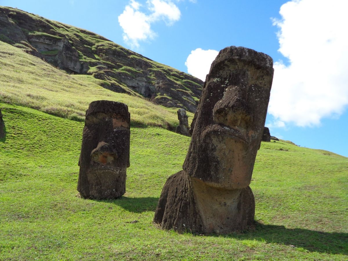
The largest moai, called Paro, was about 10 m high and weighed 75 tons. An unfinished statue 21 m high and weighing about 270 tons was also found.

About one-fifth of the moai statues had so-called pukao, which are special Polynesian red kooks also made of tuff, resembling hats.

About 95% of the existing moai were made at the Rano Raraku quarry (a volcanic crater about 700 m in diameter in the eastern part of the island, the bottom of which is occupied by a small volcanic lake), where there are still 394 moai. The quarry was suddenly abandoned for unknown reasons, and many of the statues were unfinished. Finished moai were transported from the quarry to their destination on logs and put upright with ropes. 

20
By the mid-19th century, most of the moai had been overturned.
Today, about 50 of them have been re-sited in their former places.
21
There is a legend about moai statues.
The chief of the Hotu Matu'a tribe left his homeland in search of a new home. When he died, his six sons divided the island among themselves and then their heirs. The islanders believed that the statues they erected were capable of capturing the chief's mana (supernatural power), which would lead to abundant rains and better harvests.
22
In addition to moai, there is a particular type of statue - takuturi.

Unlike moai, takuturi rest kneeling and have entirely different facial features and head shapes. Another feature that is different from moai is the place of their production and the raw material from which they were made.

Takuturi were made from scoria (a shell on the surface of lava characterized by high porosity, resulting in a porous structure) in Puna Pau (a small inactive quarry on a volcanic cone on the outskirts of the town of Hanga Roa). From there, takuturi were transported to Rano Raraku.

23
It is unknown whether the takuturi were used, like the moai, for ancestor worship and mana accumulation.
There is a theory that these statues served the cult of the bird god (Tangata manu) that developed on Rapa Nui in the last period before Europeans arrived on the island. Thus, they would prove to be the youngest moai on the island.
24
At one time, a tropical forest grew on Easter Island.

It is believed that the natives completely stripped the island of trees, using them to build boats, houses, and transport moai. Perhaps the trees disappeared because of an infestation of Polynesian rats that fed on tree seeds, preventing them from spreading.

Coconut-like palms probably grew there. They belonged to the endemic species Paschalococos disperta, which eventually died out around 1650. The trees currently growing on the island (mainly eucalyptus and acacia) are about 50 years old and were brought from Chile.

25
The island was also home to many endemic species of land and sea birds. These have become extinct due to deforestation and hunting.
Among the birds that lived there were parrots, herons, owls, rails, and seabirds: petrels and frigatebirds.
26
The people of Easter Island speak the Rapa Nui language (Vananga Rapa Nui).

It is a language from the eastern branch of the Polynesian family of Austronesian languages spoken by the island's indigenous people.

In recent decades, the language has spread to mainland Chile and other Pacific islands (especially Tahiti) due to human migration. It is spoken by nearly 5,000 people.

27
Even before the arrival of Christian missionaries on Easter Island, Rapa Nui was the only language of Oceania that had a written form.

It was written in the rongorongo script, carved in wood. Unfortunately, the language has not been deciphered to this day because a large portion of the community was abducted by Peruvian slave traders, some who could read died, and those who remained could not read.

In 1914, researcher Katherine Routledge came across a man who could read rongorongo writing. He was staying in a leper home. She reached out to him, but he refused to reveal the secret of the writing to a stranger. It is believed that he left his students on the island because the ability to write and read was passed down from generation to generation.

Research into deciphering the writing is still being conducted.

28
A macrolide antibiotic used in modern medicine was first isolated in 1975 from Streptomyces hygroscopicus bacteria from a soil sample taken on Easter Island.
The drug called Sirolimus (rapamycin) is an immunosuppressant used in transplantation. Rapamycin is also a substance that can prolong animal life, and research is being conducted into these properties.
29
The fire that invaded the island in early October 2022 caused irreversible damage to many of the statues.
The wildfire started somewhere on Tuesday, October 4th, and spread on 148.26 acres of Easter Island. Authorities claim that no amount of money put into the restoration of the statues can actually reverse the damage done.
Hungry for more facts?

Latest topics

42 facts about Kyshtym disaster
The first nuclear accident in Earth's history
Before information about it saw the light of day, the Soviets hid it for over 30 years. The explosion at the Mayak combine was the first nuclear accid ...
37 facts about Saint Petersburg
A city of many names
It was a dream and a matter of prestige for the Romanov dynasty to gain access to the Baltic Sea and build a metropolis to testify to Russia's emergin ...
32 facts about Peter the Great
The first Emperor of all Russia
Peter the Great is considered one of Russia's greatest rulers. He was a great reformer, strategist, and builder who was the first of the tsars to trav ...
39 facts about Dyatlov Pass incident
Mysterious tragedy in the Ural mountains
The case of a group of students at the Ural Polytechnical Institute in Sverdlovsk continues to arouse great interest and raise many questions. A group ...
11 facts about Brooklyn Bridge
The first steel suspension bridge in the world
It is one of the oldest suspension bridges in the world. It connects Brooklyn with Manhattan, runs over the East River, and was completed in 1883. ...
31 facts about Brazil
South America's largest country
Brazil is the largest and most populous country in South America and one of the largest and most populous countries in the world. A former Portuguese ...
44 facts about Ghent
City of three towers
Ghent is one of Belgium's most visited cities by tourists. This beautiful old Flanders city combines dignity, beauty, culture, and creativity. It is a ...
31 facts about Thailand
A country on the Indochinese Peninsula
Thailand is an Asian country located in its south-eastern part, famous for its interesting culture and religious architecture. This exotic country, wh ...

Similar topics