Santorini
Geography

Facts about Santorini

We found 27 facts about Santorini

Saint Irene island

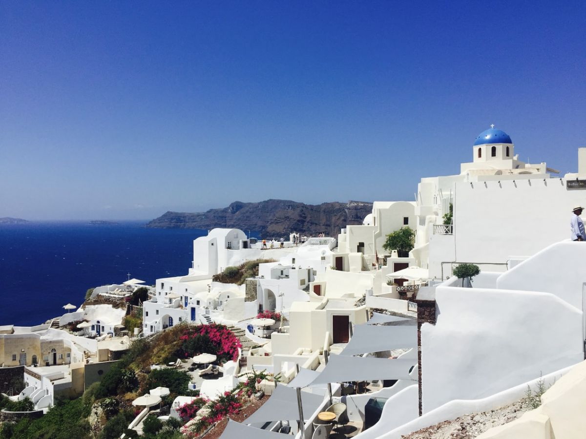
Santorini is a magical island, part of the Cyclades archipelago located in the Aegean Sea. A small but impressive piece of land with breathtaking landscape and architecture.

The island is considered one of the most beautiful places on earth. Almost everyone recognizes characteristic white buildings, narrow streets and blue dome-shaped roofs, even people who have never visited the island recollect its features for sure. Santorini is a must-see for Greek couples or honeymooners, but tourists from other countries are also warmly welcomed.

Santorini
1
Santorini is a volcanic island.
Together with four smaller islets (Tirasia, Nea Kameni, Palea Kameni, Aspronisi), it forms a small archipelago called Santorini, located in the Cyclades.
2
This Greek island is located 175 km (109 mi) southeast of the Greek coast in the Aegean Sea.
3
Modern Santorini originated as a result of a powerful volcanic eruption.
Around 1600 BC, the island, which was probably named Strongili at that time, was sunk due to a strong volcanic eruption. The volcanic explosion was so violent that it resulted in one of the world's largest calderas with a diameter of 10 km (6,2 mi). Only side fragments of the previous island remained.

The caldera is a huge depression in the top part of the volcano, resulting from a violent eruption destroying the upper part of the volcanic cone.
4
The island's capital is Fira, located on the west coast of the island, on a cliff rising to a height of 260 m (0,16 mi) above sea level.
Fira is a picturesque town on the bay, located on the caldera banks. It looks like it was carved out of a rock. It became the capital of the island in the 19th century.
5
Part of the traditional buildings of Fira was destroyed during the earthquake in 1956.
Luckily most of the historic buildings have survived to this day. The city is the administrative center of Santorini.
6
The name of the island of Santorini comes from the thirteenth century from the character of St. Irene.
Previously the island was called Kallisti, Strongili, Tera.
7
An advanced civilization lived on the island before the catastrophic eruption.
It was one of the oldest civilizations of the Bronze Age (Minoan, Cretan culture) in the Mediterranean. It began to rise around 3000 BC in Crete and peaked in the so-called period of younger palaces, around 1675-1450 BC.
8
Before the volcano eruption, an earthquake occurred. Scared inhabitants left the island just in time to avoid the worst.
The volcanic eruption caused significant damage to Crete, 110 km away, destroying Knossos Palace.
9
Researchers claim that the volcano's eruption in the 17th century BC and its collapse 300-400 m below the surface of the sea level caused a gigantic tsunami wave up to 200 m high.
10
Because of the explosion, a lot of ash escaped from the crater. Ash clouds obstructed sunlight to the entire Mediterranean region, about 300,000 km² (115 830.648 sq mi).
According to the hypothesis, the volcano ejected 60 km3 (14.39 cu mi) of magma from the crater.
11
The volcanic pumice layer of 80m (262 ft.) thick covers the sea bottom around the island in a radius of 20-30 km (12,4-18.6 mi).
12
From 300 to 500 years after the volcanic eruption, the island was uninhabited.
After that period, Dorians (a Greek people speaking a Doric dialect) settled here.
13
Santorini is located in the southern part of the Aegean Sea, in the area of ​​the Aegean Volcanic Arc's greatest activity.
Continuous observations of this area's geological activity have revealed that in 2011 the island rose about 5 cm (2 in).
14
Tourism, the primary source of income for residents, is thriving in Santorini. (except for Covid-19 lockdowns)
The island has many beaches, mainly along the south and south-eastern coast.
15
The beaches on Santorini are usually sandy and sometimes pebble.
Beaches also have different colors: white, red, and black. Usually, the name is derived from the color of sand or pebbles, but in the case of White Beach, the name comes from the white rocks above it, as the beach itself is made of black sand.
16
The islands that make up the Santorini archipelago have a surface area of approximately 90 km² (34.74 mi sq).
There are over 300 churches and small chapels in this relatively small area. Such chapels were built in the olden days when most of the local population worked at sea and set out on long, often several-month cruises. At that time, the family usually built a chapel so that its patron would protect the loved one who was at sea.
17
Characteristic of Santorini is the white, compact building with blue dome-shaped roofs.
Safety considerations regarding seismic activity dictate the construction of such shaped roofs. And under a dome, air circulation is better, which is important in a Mediterranean climate.
18
To get to the island from the port, you have to climb several hundred stairs.
You can also use a donkey or a cable car. What suits you best.
19
One of the most famous places in Santorini is Akrotiri, called "Greek Pompeii."

It was an extremely developed Minoan city, which, like Pompeii in Italy, suffered greatly from the volcanic eruption.

Archaeological works are carried out here that reveal perfectly preserved 3-story houses built of stone blocks. Among ancient walls, the Minoan vases, furniture, inscriptions in Linear B writing, and frescoes depicting scenes from everyday life have been found. One of the most famous frescoes depicts two boys carrying fish.

20
Imerovigli is the highest point above the entire caldera. It is often called the "Santorini's balcony."

It is a place with a perfect view of the panorama. From here, ancient soldiers were scouting for approaching enemy ships.

At first, it was used by the Greeks, then the Venetians who built a fortress of strategic importance on the Sykros Mountain. Around the defensive infrastructure, islanders built a settlement of about 200 houses. Until the eighteenth century, the settlement was the island's capital. The fortress and village were utterly destroyed during numerous earthquakes.

21
The highest peak of Santorini is Profitis Ilias, with a height of 567 m.

The name of the peak comes from the monastery built in 1712 at its peak. The monastery suffered a bit during the earthquake in 1956. However, it is still inhabited by the monks running the local museum.

The museum has a rich collection of icons and bibles in various editions. Some of them are rewritten by hand. The monks also produce wine, run a shoe workshop and make candles.

22
The old Theotokaki church was built in the 10th century in the town of Pyrgos.

Renovated in 1663, it is notable for its carved wooden icon screen and its old, characteristic architecture. The church boasted a Holy Icon once, but it was stolen in 1983.

The town of Pyrgos is situated on a hill. There are ruins of an old Venetian castle built on the summit.

23
On the top of the Mesa Vouno mountain are the ruins of the ancient city of Thera.
The city was inhabited in the 9th century BC. Archeologists discovered the Temple of Dionysus, the Sanctuary of Apollo, and Ancient Thera's cemetery there.
24
The town of Oia is the most photographed place on the island.
Here can find the church of St. Nicholas, patron of fishermen, and the famous windmill.
25
The wealthiest city of Santorini is Oia, which, together with Fira, presents undoubted splendor and wealth.
The picturesque view of Oia is captivating with marble roads, beautifully decorated houses, and a whole lot of other elements of architecture and landscape. Oia owes its beauty to the captains of ships who built their stately homes and led prosperous lives.
26
Santorini is also known for its beautiful sunsets, some tourists come here mainly for this reason.
27
Excellent local wines are produced there, primarily from the assyrtiko variety.
Vine bushes are low pruned and grown without supports in the dry volcanic-ash-rich soil.
Hungry for more facts?

Latest topics

42 facts about Kyshtym disaster
The first nuclear accident in Earth's history
Before information about it saw the light of day, the Soviets hid it for over 30 years. The explosion at the Mayak combine was the first nuclear accid ...
37 facts about Saint Petersburg
A city of many names
It was a dream and a matter of prestige for the Romanov dynasty to gain access to the Baltic Sea and build a metropolis to testify to Russia's emergin ...
32 facts about Peter the Great
The first Emperor of all Russia
Peter the Great is considered one of Russia's greatest rulers. He was a great reformer, strategist, and builder who was the first of the tsars to trav ...
39 facts about Dyatlov Pass incident
Mysterious tragedy in the Ural mountains
The case of a group of students at the Ural Polytechnical Institute in Sverdlovsk continues to arouse great interest and raise many questions. A group ...
11 facts about Brooklyn Bridge
The first steel suspension bridge in the world
It is one of the oldest suspension bridges in the world. It connects Brooklyn with Manhattan, runs over the East River, and was completed in 1883. ...
31 facts about Brazil
South America's largest country
Brazil is the largest and most populous country in South America and one of the largest and most populous countries in the world. A former Portuguese ...
44 facts about Ghent
City of three towers
Ghent is one of Belgium's most visited cities by tourists. This beautiful old Flanders city combines dignity, beauty, culture, and creativity. It is a ...
31 facts about Thailand
A country on the Indochinese Peninsula
Thailand is an Asian country located in its south-eastern part, famous for its interesting culture and religious architecture. This exotic country, wh ...

Similar topics